"Cape Haze is a Florida place where the sense of wilderness and encounters with the genuinely wild persist-- where there remains the chance to experience our state's original bounty and heritage of nature. That's what aquatic preserves are all about."
- Ernest D. Estevez, Ph.D., Director at the Center for Coastal Ecology, Mote Marine Laboratory

Cape Haze Aquatic Preserve is east of Boca Grande, surrounded by Gasparilla Sound-Charlotte Harbor Aquatic Preserve and Charlotte Harbor Preserve State Park. This aquatic preserve is a maze of islands and shallow passages, where Catfish and Whidden creeks meet Charlotte Harbor to mix with water from the Gulf of Mexico.
An intricate network of mangrove forests and seagrass meadows provides rich habitats for all life stages of shellfish, crustaceans and fishes, including more than 100 invertebrate species and 200 fish species.
The quiet islands serve as important bird rookeries for the roosting and nesting wading and diving birds. Kayaking, birding and fishing are recreational activities compatible with these shallow waters. Clam aquaculture and crabbing are local commercial enterprises. More than 70% of commercially important fish and shellfish species rely on estuaries at some stage of their lives.

Aquatic preserves staff and volunteers routinely monitor water quality and natural resources in the bay, such as seagrasses and nesting birds.
Ongoing programs include:
Education and Outreach: Aquatic preserves staff provide educational materials, scientific data and outreach presentations upon request. Visitors are encouraged to learn about Charlotte Harbor Aquatic Preserves via Nature Boat and Snorkel Ecoventures.
Learn more about the aquatic preserves by visiting the Friends of Charlotte Harbor's website.
There are no developments immediately adjacent to Cape Haze Aquatic Preserve because of the establishment of the Charlotte Harbor Preserve State Park. Island Bay National Wildlife Refuge is located in Cape Haze Aquatic Preserve, providing an additional level of protection to certain mangrove islands in this pristine area.
Kayaking, birding and fishing are recreational activities compatible with these shallow waters.
Florida’s coastal areas, especially uplands adjacent to water, often have a rich history of human settlement. Human activity within CHAP and Charlotte Harbor Preserve State Park dates back to the Archaic period, 10,500 – 3,000 B.P. There are hundreds of historic or archeological sites recorded in the Florida Master Site File within or immediately adjacent (i.e., within 50 meters or 164 feet) to CHAP, most of which are within CHAP boundaries. However, much of the area has not been surveyed, and it is expected that there are still unrecorded sites located along the coastline of the uplands, on islands and in inundated areas.
These historic sites include Native American and European encampments and villages and shipwrecks, along with prehistoric shell kitchen middens.
While there are many recorded sites, the prehistoric cultural sequence for the coastal areas around CHAP is still incompletely understood, particularly the earlier pre-ceramic occupations. Part of the problem centers on the fact that there has been an overall 30-50 meter rise in sea level in the past 10,000 to 12,000 years. Thus, the majority of the coastal sites from these earliest periods lie on the bottom of the Gulf of Mexico and the extensive bay system comprising the aquatic preserves.
With more than 40 archeological sites, Cape Haze Aquatic Preserve has a wealth of prehistoric remnants of early Florida native peoples.
Mollusk reefs, perhaps the most impacted natural habitat type in CHAP, are expansive concentrations of sessile mollusks (usually the Eastern oyster in Florida) occurring in intertidal and subtidal zones to a depth of 40 feet, and are typically referred to as oyster reefs or oyster beds. Oyster reef habitat provides numerous ecosystem services: They are essential fish habitat, bio-assimilate nutrients, filter water, reduce turbidity and stabilize shorelines, among numerous other functions. Tolley, Volety and Savarese (2005) studied the resident communities of oyster reefs in the Caloosahatchee estuary and identified 10 species of decapods and 16 species of fish living on the oyster reef.
At least 90% of oyster reef habitat in the Charlotte Harbor region is estimated to have been lost as a result of dredging, mining for road beds, hydrologic changes and harvesting (Boswell, Ott, Birch, & Cobb, 2012). Natural predators impacting mollusk reefs within CHAP include stone crabs, blue crabs, oyster drills (Stramonita haemastoma), sheepshead (Archosargus probatocephalus), black drum (Pogonias cromis) and other fishes and invertebrates.
The relative abundance (0.1%) of oyster reef is low throughout CHAP. Lemon Bay and Cape Haze aquatic preserves have a slightly higher percentage (0.2%) of oyster reefs than the other aquatic preserves.
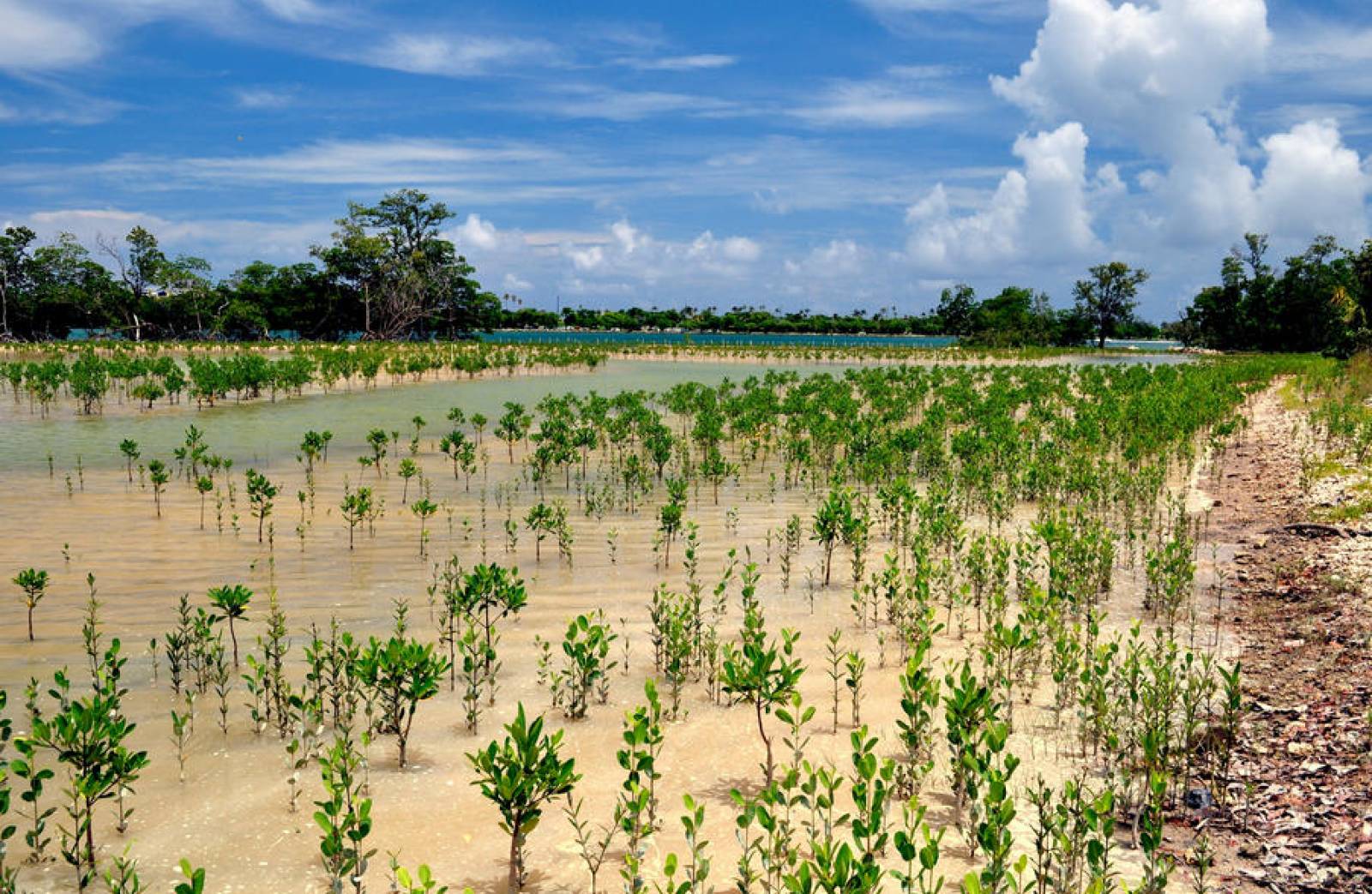
Mangrove swamps are dense, low forests occurring along relatively flat, intertidal and supratidal shorelines of low wave energy along southern Florida. Four species of trees are naturally found in mangrove swamps: red mangrove, white mangrove (Laguncularia racemosa), black mangrove (Avicennia germinans) and buttonwood (Conocarpus erectus). Birds utilize mangrove swamps as nesting habitat, and fish use their roots as nursery grounds and as protection from predators. Mangroves also stabilize substrates and shorelines.
More than 5% of CHAP is composed of mangrove swamp, including most of the CHAP shoreline.
Threats to mangrove habitat include wide-spread trimming and removal, conversion to hardened shorelines, exotic vegetation and sea level rise. Coastal development including sea walls contributes to the loss of the mangrove shoreline and is most apparent in Lemon Bay Aquatic Preserve. Natural events such as hurricanes can also affect mangrove swamps, including Hurricane Charley which caused degradation of mangroves throughout CHAP in 2004. Although some mangrove islands were totally lost, most areas have recovered.
Brazilian pepper (Schinus terebinthifolius), carrotwood (Cupaniopsis anacardioides) and seaside mahoe (Thespesia populnea) are three invasive exotic species that can be found within mangrove swamps. Red mangroves have been designated as an essential feature of sawfish critical habitat.
Seagrass beds are the most abundant vegetated habitat type in CHAP. Seagrasses are not true grasses, but are flowering plants (angiosperms) that live underwater. Like land plants, seagrasses produce oxygen and store carbon, which are two important functions. The depth at which seagrasses are found is limited by water clarity because they require sunlight; each species has specific light requirements, allowing some to grow deeper than others.
Seagrasses are a sensitive indicator of water quality and pollution in shallow coastal areas as they are vulnerable to various forms of anthropogenic stress. Seagrasses are also susceptible to scarring from boat propellers, anchors and trawls. While seagrasses will recolonize areas when water quality is good and disturbances are removed, re-vegetation of scarred areas may require many years. Reccurring disturbances such as prop scarring and dredging can result in permanent seagrass loss.
Seagrass beds make up around 50% of the natural communities in each of the aquatic preserves, except Gasparilla Sound-Charlotte Harbor Aquatic Preserve which is characterized by much deeper water. Eighty percent of the seagrass beds in CHAP are mapped as continuous, while the rest are discontinuous or patchy. Continuous seagrass beds are characterized by a uniform signature on aerial photos with only small sandy-bottom patches (less than one-quarter acre) within the bed; discontinuous or patchy seagrass beds are areas with isolated patches of seagrass interspersed with open bottom.
Seagrass communities occur in subtidal (rarely intertidal) zones, in clear coastal waters where wave energy is moderate. Aquatic preserve personnel monitor six seagrass species within CHAP: turtle grass, manatee grass (Syringodium filiforme), shoal grass, star grass (Halophila engelmannii), paddle grass (Halophila decipiens) and widgeon grass (Ruppia maritima). The salinity tolerance of the species varies and along with light availability dictates where each will be found. Listed species such as the state and federally endangered Florida manatee, Atlantic green turtle (Chelonia mydas), Atlantic hawksbill turtle (Eretmochelys imbricata), and the state and federally listed threatened Atlantic loggerhead turtle (Caretta caretta) all rely on seagrass bed communities. Together, seagrasses and their epiphytes serve as important food sources and nursery areas to a myriad of species.
Often, numerous species of epiphytic algae, egg casings and invertebrates attach to the seagrass leaf blades.
Sponge beds are characterized as dense populations of sponges. Although concentrations of living sponges can occur in marine and estuarine intertidal zones, sponge beds are confined primarily to subtidal zones. There are no currently mapped sponge beds in CHAP. Individual sponges occur sporadically throughout CHAP, and sponge beds may be present.
Unconsolidated substrates are expansive, relatively open areas of subtidal, intertidal and supratidal unsolidified materials that lack dense populations of sessile plant and animal species. This community may support a large population of infaunal organisms as well as a variety of transient planktonic and pelagic organisms. Furthermore, according to a study by J. Schmid in 2009, unvegetated bottom with colonies of sessile invertebrates such as tube worms, tunicates, bryozoans and sponges (i.e., live bottom) has been identified as essential foraging habitat for the endangered Kemp’s ridley turtle (Lepidochelys kempii) in the coastal waters of west Florida.
This community is known to make up the majority of the unclassified submerged bottom areas within CHAP. It is found not only in deeper waters such as channels but also in some of the shallowest and intertidal portions of the bay, where seagrasses are not found. The only mapped areas of unconsolidated substrate are tidal flats - areas of sand or mud that are unvegetated and cycle between being submerged and exposed with the change in tides.
Tidal flats make up less than 5% of CHAP but more than 10% of Cape Haze and Matlacha Pass aquatic preserves. During daylight hours, tidal flats serve as a primary feeding ground for numerous species of shorebirds and wading birds. During the night, fish, crabs and shrimp become the major consumers. Primary producers of mudflats include diatoms, dinoflagellates, filamentous green algae and blue-green algae. While these areas can appear relatively barren, the densities of infaunal organisms in subtidal zones can reach the tens of thousands per square meter, making these areas important feeding grounds for many bottom-feeding fish.
Consolidated substrates are mineral-based natural communities generally characterized as expansive, relatively open areas of subtidal, intertidal and supratidal zones that lack dense populations of sessile plant and animal species. Consolidated substrates are solidified rock or shell conglomerates and include coquina, limerock or relic mollusk reef materials. These communities may be sparsely inhabited by sessile, planktonic, epifaunal and pelagic plants and animals but house few infaunal organisms (i.e., animals living within the substrate).
Consolidated substrates are important in that they form the foundation for the development of other marine and estuarine natural communities when environmental conditions become appropriate. Consolidated substrates are not mapped in CHAP, but small localized areas are known and include areas along the eastern shoreline of Charlotte Harbor including Alligator Creek and Pirate Harbor.
| Natural Community | Acreage |
|---|---|
| Mollusk Reef | 30 |
| Mangrove Swamp | 1,467 |
| Seagrass Bed | 6,185 |
| Unconsolidated Substrate | 1,323 |
| Sponge Beds | Unknown |
| Consolidated Substrate | Unknown |
| Unclassified | 3,711 |
Interested in subscribing to DEP newsletters or receiving DEP updates through email?
Sign UpThe Florida Department of Environmental Protection is the state’s lead agency for environmental management and stewardship – protecting our air, water and land. The vision of the Florida Department of Environmental Protection is to create strong community partnerships, safeguard Florida’s natural resources and enhance its ecosystems.
Learn More